
Market Report · July 24, 2026

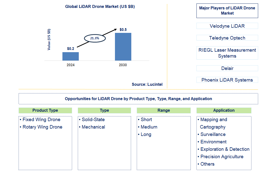
Key data points: The market size in 2031 = $0.7 billion, growth forecast = 21.3% annually for the next 7 years. Scroll below to get more insights. This market report covers trends, opportunities, and forecasts in the global lidar drone market to 2031 by product type (fixed wing drone and rotary wing drone), type (solid-state and mechanical), range (short, medium, and long), application (mapping and cartography, surveillance, environment, exploration & detection, precision agriculture, and others), and region (North America, Europe, Asia Pacific, and the Rest of the World)
We'll send your sample report shortly.
• Lucintel forecasts that, within the product type category, rotary is expected to witness the higher growth over the forecast period due to the growing use of single-rotor and multi-rotor uavs globally, given to its affordability, stability, and quick positioning of the drones.
• In terms of regions, North America will remain the largest region over the forecast period due to the quick adoption of innovative technologies, the existence of favorable drone flying laws, and the presence of key manufacturers in the region. Gain valuable insights for your business decisions with our comprehensive 150+ page report.
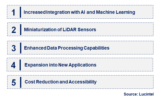
• Increased integration with AI and machine learning: LiDAR drones are increasingly incorporating AI and machine learning to enhance data analysis and automate processing. This integration allows for more accurate interpretation of complex datasets and improves decision-making in applications such as environmental monitoring and urban planning.
• Miniaturization of LiDAR sensors: Advances in miniaturization are making LiDAR sensors smaller and lighter, enabling their integration into compact drones. This trend enhances the versatility and deployment of LiDAR drones in various environments, including difficult-to-access areas and smaller drones.
• Enhanced data processing capabilities: There is a growing emphasis on improving data processing capabilities, including real-time data analysis and advanced visualization tools. This trend supports faster decision-making and more detailed insights, benefiting industries such as construction and infrastructure management.
• Expansion into new applications: LiDAR drones are finding new applications beyond traditional surveying and mapping. Emerging uses include precision agriculture, forestry management, and disaster response, reflecting the growing versatility and utility of LiDAR technology.
• Cost reduction and accessibility: Efforts to reduce the cost of LiDAR drones and sensors are making these technologies more accessible. This trend is driving adoption in smaller enterprises and developing regions, expanding the market and increasing overall usage. These trends are reshaping the LiDAR drone market by driving technological advancements, expanding applications, and increasing accessibility, ultimately fostering growth and innovation across various sectors.
• LiDAR sensor technology: The development of sensor technology has ensured improvement in the fields of accuracy, range, and resolution. Such developments improve data quality and enable applications needing a high degree of accuracy, such as topographic mapping and inspection of infrastructure.
• Integration with real-time data processing: LiDAR drones are increasingly incorporating real-time data processing capabilities. This integration enables immediate analysis and feedback, improving the efficiency of operations and decision-making in dynamic environments like disaster response and construction.
• More battery life and flight time: Advancements in battery technology are further increasing the flight time for LiDAR drones. Increased flight time means greater data collection can be performed on a single flight, enhancing the capability to perform surveying and mapping efficiently.
• Advanced integration with software: Advanced software is being developed to visualize and interpret data from LiDAR drone mapping. This software provides more enhanced functionalities for interpretation and reporting, which are important aspects of industry applications like agriculture and urban planning.
• Specialized drones: This class comprises configurations and custom functions developed according to unique requirements for different sectors, such as LiDAR drones designed for forestry or agriculture applications. There has been an emergence of specialized LiDAR drones to suit different specific applications, like forestry or agriculture. Such advancements in technology, increased efficiency, and wider application areas are driving growth and innovation in huge strides in the LiDAR drone market space.
• Urban planning and development: LiDAR drone are finding increasing sales on account of the high-accuracy data that can be captured for urban planning and development projects. Infrastructure mapping, land-use analysis, and environmental impact assessments can be well updated through this technology.
• Precision farming and agriculture: LiDAR drone find their application in agriculture for precision farming techniques such as crop monitoring and soil analysis. This application will be helpful in optimizing resources, improving yields, and enhancing the overall management of farms.
• Environmental monitoring and conservation: LiDAR drone are key tools in environmental monitoring and conservation. Applications include forest inventory, mapping of habitats, and environmental impact assessments, supporting conservation and sustainable management.
• Construction and infrastructure inspection: LiDAR drone have been increasingly used in monitoring construction and infrastructure improvements, where the process includes the assessment of structural integrity and observance of regulations. This application helps enhance project management in terms of efficiency and effectiveness.
• Disaster response and management: LiDAR drone are widely used in response to and management of disasters, providing real-time data on damage assessment for rescue operations and recovery planning. This application enhances the effectiveness of emergency response efforts. All these factors point toward growing applications of LiDAR drone that drive market development and innovation in several other sectors.
• Technological Advancement: Advancements in LiDAR sensor technologies and drone platforms are continuous, which, in turn, drives market growth. Improved accuracy and resolution, along with increased data processing, enable a wide range of applications, from mapping to environmental monitoring.
• Increasing Applications: The applications of LiDAR drone have been rising, from environmental monitoring to disaster response applications. This trend will continue to drive the market upward. More importantly, the demand for LiDAR technology will lead to new use cases for the technology.
• Reducing Cost and Accessibility: Ongoing efforts to reduce the cost of LiDAR drone and sensors will increase access to this technology for more users. Lower costs facilitate adoption in developing regions, particularly among smaller enterprises. Challenges in the LiDAR drone market include:
• Regulatory and Compliance Issues: Compliance with regulatory requirements makes it difficult for both manufacturers and users of LiDAR drone to operate. Meeting regulatory requirements involves balancing adherence and operational costs, forcing manufacturers and service providers to strive for greater efficiency to remain competitive in the market.
• High Initial Investment Costs: The high initial investment cost of purchasing LiDAR drone and associated technologies is unaffordable for some users. How manufacturers balance these challenges with other competing issues is critical.
• Technological Complexity: Integrating LiDAR sensors with drone brings a host of technical issues. To maintain high functionality and flawless operation, continuous innovation and expertise are required. These drivers and challenges have combined effects on the growth trajectory of the LiDAR drone market, influencing strategic decisions. Balancing technological advancements with cost management and adherence to regulatory requirements is the key to success in this evolving industry.
• Velodyne LiDAR
• Teledyne Optech
• RIEGL Laser Measurement Systems
• Delair
• Phoenix LiDAR Systems
• Leica Geosystems
• Yellow Scan
• LiDARUSA
• SZ DJI Technology
• Benewake
• Fixed Wing Drone
• Rotary Wing Drone
• Solid-State
• Mechanical
• Short
• Medium
• Long
• Mapping and Cartography
• Surveillance
• Environment
• Exploration & Detection
• Precision Agriculture
• Others
• North America
• Europe
• Asia Pacific
• The Rest of the World
• United States: In the U.S., developments include attaching advanced LiDAR sensors to drone to enhance data accuracy and efficiency. Recent innovations focus on improving range resolution and real-time data processing, with applications in mapping, infrastructure inspection, and disaster response.
• China: China is upgrading LiDAR drone technology to make it cost-effective for mass adoption. Improvements in drone flight stability and LiDAR sensor performance are facilitating widespread use in urban planning, agriculture, and environmental monitoring.
• Germany: Germany is leading in developing high-precision LiDAR drone for industrial use. Recent advancements emphasize robustness and advanced software integration, allowing for better data analytics and visualization, supporting sectors like construction and forestry.
• India: The Indian market is seeing growth in LiDAR drone, with a focus on finding cost-effective and efficient solutions. Advancements include increased accessibility to high-resolution LiDAR systems and integration with GIS software, enhancing applications in land surveying and infrastructure development.
• Japan: Japan is well positioned to advance LiDAR drone technology with miniaturization and integration of other high-tech technologies, such as enhanced durability and precision. Developments have improved its ability to perform in agriculture, disaster management, urban planning, and many other applications.
• Velodyne LiDAR
• Teledyne Optech
• RIEGL Laser Measurement Systems
• Delair
• Phoenix LiDAR Systems
• Leica Geosystems
• Yellow Scan
• LiDARUSA
• SZ DJI Technology
• Benewake Q6. Which LiDAR drone market segment will be the largest in future? Answer: Lucintel forecasts that rotary is expected to witness the higher growth over the forecast period due to growing use of single-rotor and multi-rotor uavs globally given to its affordability, stability, and quick positioning of the drones. Q7. In LiDAR drone market, which region is expected to be the largest in next 5 years? Answer: North America will remain the largest region over the forecast period due to quick adoption of innovative technologies, existence of favorable drone flying laws, and presence of key manufacturers in the region. Q.8 Do we receive customization in this report? Answer: Yes, Lucintel provides 10% customization without any additional cost.


Choose a license that fits your team. Instant PDF delivery.
Prices exclude taxes. Instant delivery. Custom licensing available on request.
Market Report · July 24, 2026
Market Report · July 20, 2026
Market Report · July 20, 2026
Trusted partner for strategic intelligence and business growth


Receive a complimentary market analysis tailored to your industry. Our analysts will identify key growth opportunities and competitive dynamics specific to your business.

Market size, growth rate, and key trend analysis for your specific sector.

Top competitor positioning and market share analysis.

Strategic recommendations backed by data-driven insights.
Get curated market intelligence and competitive moves straight to your inbox.
By subscribing, you agree to receive our monthly insights. Unsubscribe anytime.
Receive a complimentary market analysis tailored to your industry. Our analysts will identify key growth opportunities and competitive dynamics specific to your business.
Market size, growth rate, and key trend analysis for your specific sector.
Top competitor positioning and market share analysis.
Strategic recommendations backed by data-driven insights.
Get curated market intelligence, emerging trends, and competitive moves straight to your inbox each month.
By subscribing, you agree to receive our monthly insights. Unsubscribe anytime.
We'll send your sample report shortly.