Market Report · July 15, 2026

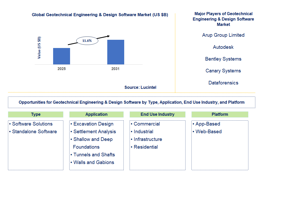
Key data points: The growth forecast = 11.6% annually for the next 7 years. Scroll below to get more insights. This market report covers Trends, opportunity and forecast in geotechnical engineering & design software market to 2031 by type (software solutions and standalone software), application (excavation design, settlement analysis, shallow and deep foundations, tunnels and shafts, and walls and gabions), end use industry (commercial, industrial, infrastructure, and residential), platform (app-based and web-based), and region (North America, Europe, Asia Pacific, and the Rest of the World)
We'll send your sample report shortly.
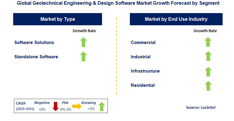
• Lucintel forecasts that, within the type category, standalone software will remain larger segment over the forecast period.
• Within the application category, infrastructure is expected to witness higher growth.
• In terms of region, APAC is expected to witness the highest growth over the forecast period. Gain valuable insights for your business decisions with our comprehensive 150+ page report. Sample figures with some insights are shown below.
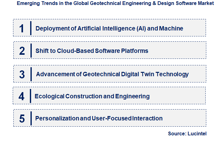
• Deployment of Artificial Intelligence (AI) and Machine Learning (ML): AI and ML are transforming the geotechnical software landscape. Advanced technologies enable forecasting of soil behavior, risk evaluation, and design optimization. These developments improve simulation accuracy, allowing engineers to make informed decisions during design and other complex tasks.
• Shift to Cloud-Based Software Platforms: Geotechnical software is being adopted more rapidly as it facilitates real-time collaboration and data sharing. These platforms enable remote work, increasing flexibility for project teams and reducing time and costs associated with managing large-scale projects. Cloud solutions also integrate with other construction tools, streamlining workflows across disciplines.
• Advancement of Geotechnical Digital Twin Technology: Geotechnical digital twin technology is growing rapidly, enabling the creation and use of digital models that provide virtual representations of real-world systems. Digital twins allow engineers to monitor and assess performance using simulations based on real-world conditions, predicting potential concerns long before they occur. This is highly valuable for managing large infrastructure projects while maintaining safety.
• Ecological Construction and Engineering: As software capabilities improve, designing eco-efficient and resilient geotechnical structures is becoming easier. With new regulations requiring buildings to be environmentally conscious, new tools are being developed to assess and mitigate the impacts of construction. These innovations aim to promote sustainable construction practices globally.
• Personalization and User-Focused Interaction: Geotechnical software is becoming more user-focused, offering features that can be customized for specific project requirements. Improved visualization capabilities make these tools more accessible to non-experts, ensuring that geotechnical engineers can evaluate complex data sets accurately and efficiently, thus enhancing the design process. These trends are reshaping the market by increasing precision, scalability, and eco-friendliness in geotechnical engineering design. The focus is also shifting toward optimizing construction technologies.
• OpenGround Cloud by Bentley Systems: OpenGround Cloud by Bentley Systems is an innovative cloud-based platform for managing geotechnical data, enabling real-time collaboration, data sharing, and better integration of workflows, streamlining collaboration across teams. OpenGround Cloud transforms how geotechnical data is managed by allowing teams to access real-time data for better analysis, helping keep projects on schedule.
• MIDAS GTS NX by MIDAS IT: MIDAS IT has launched MIDAS GTS NX, an advanced software for geotechnical analysis that includes sophisticated 3D modeling. It offers advanced simulation and optimization tools, easing the task of modeling and analyzing complex ground behavior in tunnel and foundation design.
• Update on RS3 Software by Rocscience: The RS3 software update by Rocscience enhances tools for rock and soil analysis. Several new features have been added, including better performance, improved user interfaces, more accurate geotechnical simulations, and refined engineering processes for tunneling, mining, and other subsurface projects, helping engineers in their work.
• Autodesk's Acquisition of Innovyze: Autodesk recently acquired Innovyze, a leader in environmental and water infrastructure software. This acquisition will further expand Autodesk's geotechnical capabilities, positioning it as a stronger player in the market and providing additional value to civil engineering through integrated solutions for water management and soil behavior.
• Geotechnical Software Integration with BIM by Nemetschek: New geotechnical software solutions developed by Nemetschek integrate directly with BIM platforms, enabling better data transfer between engineering disciplines. This seamless workflow allows engineers to incorporate geotechnical analysis into construction, greatly improving project success by ensuring that subsurface data informs all design phases. Innovations in geotechnical engineering software continue to shape the industry with enhanced collaboration, precision, and ingenuity, reinforcing the future of the field.
• Infrastructure Development Projects: The use of geotechnical engineering software is rapidly increasing with the construction of highways, bridges, and buildings. These projects are closely linked to urbanization, which is at an all-time high. These initiatives require enhanced geotechnical and subsurface modeling, driving the demand for sophisticated risk assessment tools.
• Projects with a Sustainability Focus: There is now greater emphasis on sustainable projects, creating a market opportunity for software that assists in designing materials with low environmental impact.
• Seismic Risk Management: The integration of seismic risk analysis is especially important for geotechnical software in countries like Japan and the U.S. There is considerable opportunity in earthquake-prone regions for software that models the effects of earthquakes on soil and structures.
• Mining and Resource Extraction: In the mining sector, geotechnical software is essential for modeling soil and groundwater relations, as accuracy is critical. As resource extraction challenges increase, the demand for custom software capable of modeling geotechnical parameters is rising.
• Smart Cities and Digital Infrastructure: With the development of smart cities and other digital infrastructure projects, there is a growing need for advanced software systems. These systems could integrate IoT sensors, real-time data streams, and digital twins of utility networks, enabling better monitoring and management of subsurface data for urban planning and maintenance. These opportunities highlight the increasing significance of geotechnical software in various industries, providing a strong market for future innovation and growth.
• Arup Group Limited
• Autodesk
• Bentley Systems
• Canary Systems
• Dataforensics
• Daystar Software
• DC-Software Doster & Christmann GmbH
• Software Solutions
• Standalone Software
• Excavation Design
• Settlement Analysis
• Shallow and Deep Foundations
• Tunnels and Shafts
• Walls and Gabions
• North America
• Europe
• Asia Pacific
• The Rest of the World
• United States: There is a growing trend in the U.S. toward using Bentley OpenGround Cloud for timely geotechnical design tasks. This platform offers enhanced performance due to its support of real-time collaboration and seamless information exchange between interdisciplinary teams. Moreover, the integration of AI and machine learning technologies allows for more accurate simulation of soil dynamics and geotechnical risk assessment, resulting in improved design decisions and overall accuracy.
• China: China is extensively investing in the adoption of geotechnical engineering software for critical infrastructure projects such as railways, highways, and bridges. Advanced tools for foundation optimization, seismic risk assessment, and slope stability are becoming increasingly important in urban construction. There is also a growing effort to produce bespoke geosoftware within China, addressing local geoengineering challenges, which will help develop more resilient and sustainable infrastructure.
• Germany: Germany is a world leader in using geotechnical engineering software for building information modeling (BIM), which integrates geotechnical engineering with geomatics. This approach enhances project execution by improving collaboration and information exchange between architects, civil engineers, and construction teams. This is particularly evident in innovations by Nemetschek, which aids in the accurate depiction of below-ground structures and compliance with legal standards for optimal designs based on German engineering excellence.
• India: Growth in infrastructure development is driving the demand for geotechnical software. Local solutions are tailored to address issues such as soil heterogeneity, groundwater management, and highly engineered deep structures. These solutions are becoming more accessible due to the use of AI and cloud computing, supporting large-scale infrastructure development across the country.
• Japan: Japan leads the world in using digital twin technology in geotechnical engineering software. Given the growing challenges of managing seismic risks, software incorporating AI and real-time data streams allows engineers to monitor and predict soil behavior and seismic effects with greater precision. Innovations like GeoSim.AI are revolutionizing how simulations and numerical modeling are performed in Japan.
• Arup Group Limited
• Autodesk
• Bentley Systems
• Canary Systems
• Dataforensics
• Daystar Software
• DC-Software Doster & Christmann GmbH Q5. Which geotechnical engineering & design software market segment will be the largest in future? Answer: Lucintel forecasts that standalone software will remain larger segment over the forecast period. Q6. In geotechnical engineering & design software market, which region is expected to be the largest in next 5 years? Answer: APAC is expected to witness the highest growth over the forecast period. Q7. Do we receive customization in this report? Answer: Yes, Lucintel provides 10% customization without any additional cost.


Choose a license that fits your team. Instant PDF delivery.
Prices exclude taxes. Instant delivery. Custom licensing available on request.
Market Report · July 15, 2026
Market Report · June 26, 2026
Market Report · June 24, 2026
Trusted partner for strategic intelligence and business growth


Receive a complimentary market analysis tailored to your industry. Our analysts will identify key growth opportunities and competitive dynamics specific to your business.

Market size, growth rate, and key trend analysis for your specific sector.

Top competitor positioning and market share analysis.

Strategic recommendations backed by data-driven insights.
Get curated market intelligence and competitive moves straight to your inbox.
By subscribing, you agree to receive our monthly insights. Unsubscribe anytime.
Receive a complimentary market analysis tailored to your industry. Our analysts will identify key growth opportunities and competitive dynamics specific to your business.
Market size, growth rate, and key trend analysis for your specific sector.
Top competitor positioning and market share analysis.
Strategic recommendations backed by data-driven insights.
Get curated market intelligence, emerging trends, and competitive moves straight to your inbox each month.
By subscribing, you agree to receive our monthly insights. Unsubscribe anytime.
We'll send your sample report shortly.