
Market Report · July 22, 2026

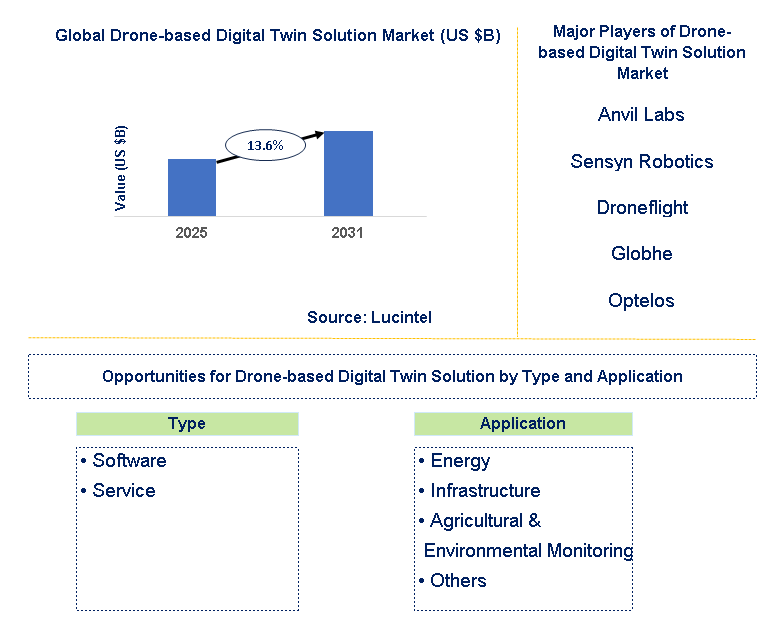
Key data points: The growth forecast = 13.6% annually for the next 7 years. Scroll below to get more insights. This market report covers Trends, opportunities and forecasts in drone-based digital twin solution market to 2031 by type (software and service), application (energy, infrastructure, agricultural & environmental monitoring, and others), and region (North America, Europe, Asia Pacific, and the Rest of the World)
We'll send your sample report shortly.
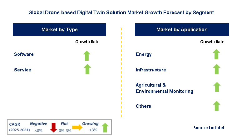
• Lucintel forecasts that, within the type category, service is expected to witness higher growth over the forecast period.
• Within the application category, infrastructure is expected to witness the highest growth.
• In terms of region, APAC is expected to witness the highest growth over the forecast period.
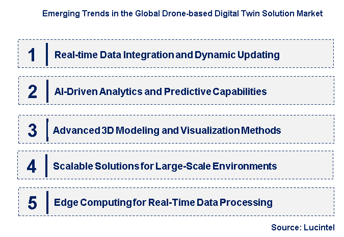
• Real-time Data Integration and Dynamic Updating: One of the major trends is the growing capability to integrate real-time data streams from drones and other sensors (e.g., IoT devices, ground monitors) directly into digital twin platforms. This allows for dynamic updating of digital twins, showing the latest status and conditions of physical assets and environments in near real time. The effect is increased situational awareness, enhanced monitoring capacity, and the capacity to make more timely and data-informed decisions based on the most current information gathered by drones.
• AI-Driven Analytics and Predictive Capabilities: The combination of Artificial Intelligence (AI) and Machine Learning (ML) algorithms with data gathered by drones in digital twin environments is a significant upcoming trend. AI/ML facilitates sophisticated analytics, including autonomous defect identification in infrastructure, predictive maintenance scheduling for equipment, and resource allocation optimization in city planning. The benefit is the potential to draw deeper insights from digital twins, forecast potential problems, and optimize operations ahead of time, resulting in substantial cost reductions and enhanced efficiency.
• Advanced 3D Modeling and Visualization Methods: Progress in data capture using drones, such as high-resolution photogrammetry and LiDAR scanning, is enabling more precise and detailed 3D models for digital twins. In addition, advances in visualization technologies, such as virtual reality (VR) and augmented reality (AR), are making users' interaction with and insights from these digital twins more efficient. The effect is more intuitive and immersive experiences with digital twins, enabling improved understanding, collaboration, and decision-making among different stakeholders.
• Scalable Solutions for Large-Scale Environments: There is an increasing need for drone-based digital twin solutions that can effectively capture and manage data for large-scale environments, like entire cities, large infrastructure networks (e.g., power grids, transportation corridors), and vast agricultural fields. Advances in fleet management of drones, autonomous flight planning, and optimized data processing pipelines are now enabling the production and upkeep of digital twins for these large expanses. The result is that it is becoming possible to attain full insights and govern intricate systems at a previously unimaginable scale.
• Edge Computing for Real-Time Data Processing: In order to contend with the high amounts of data created by drones, particularly around real-time uses, several emerging trends such as the use of edge computing are being employed. Data processing near the point of origin (i.e., on the drone or at the site where data is collected) minimizes latency while lowering bandwidth demands. This allows for quicker analysis and creation of real-time insights. The effect is faster access to actionable information, allowing real-time decision-making and control in applications such as disaster response, infrastructure monitoring, and autonomous systems. These new trends together are redefining the drone-based digital twin solution market to make it more real-time, intelligent, visually rich, scalable, and efficient. The fusion of cutting-edge technologies such as AI, ML, AR/VR, and edge computing with data from drones is opening new avenues for digital twin creation and utilization across industries in a broad range.
• Enhanced Drone Payload Technologies: The latest advancements in drone payload technologies, such as higher-res cameras, advanced LiDAR technology that offers greater accuracy and range, and multispectral/hyperspectral sensors, are making it possible to capture richer and more accurate data for digital twin development. These innovations lead to more precise and information-rich digital twins, making analysis and insights more accurate.
• Automated Drone Data Acquisition Workflows Development: There is an increasing emphasis on automating the whole drone data acquisition process to create digital twins. This includes the development of autonomous flight planning software, automatic drone deployment and operation, and optimized data processing pipelines. Automation minimizes human intervention, maximizes efficiency, and allows more frequent and low-cost data updates for digital twins.
• Integration with Enterprise Software Systems: One major evolution is growing integration of drone-based digital twin solutions with prevailing enterprise software systems, including Geographic Information Systems (GIS), Building Information Modeling (BIM) software, Enterprise Asset Management (EAM) systems, and Computerized Maintenance Management Systems (CMMS). Through such integration, seamless information sharing and automated workflow are achieved, increasing usability and value of digital twins across organizational workflows.
• Cloud-Based Digital Twin Platform Advancements: The creation of scalable and secure cloud-based platforms for hosting, managing, and analyzing digital twin models and data captured by drones is a major trend. Cloud platforms provide advantages like increased accessibility, collaboration features, and the capacity to process large datasets, making digital twins more accessible and usable across various teams and locations.
• Industry-Specific Digital Twin Solutions: A trend towards creating custom digital twin solutions that cater to the unique requirements and pain points of specific industries, including construction, energy, agriculture, and transportation, is on the rise. Industry-specific solutions typically include domain-specific analytics and visualization, which makes them more relevant and impactful to users in these industries. These critical advancements are having a material influence on the drone-based digital twin solution market by enhancing data capture efficiency and accuracy, enhancing the availability and integration of digital twins in enterprise systems, and supporting the development of industry-focused solutions that provide real business benefits.
• Infrastructure Asset Management: A significant growth area is applying drone-based digital twins for the maintenance of key infrastructure assets like bridges, roads, rail, power lines, and pipelines. Digital twins provide in-depth inspection, condition monitoring, predictive maintenance, and asset lifecycle management, resulting in cost reductions, increased safety, and longer asset life.
• Construction and Project Management: Creating digital twins of construction sites using drone surveys provides valuable insights for project planning, progress tracking, quality control, and safety management. Real-time updates from drones enable better decision-making, reduced delays, and improved collaboration among stakeholders.
• Urban Planning and Smart Cities: Drone-based digital twins provide effective tools for urban planning, such as 3D city modeling, traffic flow analysis, environmental monitoring, and infrastructure development. These digital forms make it possible to make better urban design, resource management, and the development of smarter, more sustainable cities.
• Precision Farming and Agriculture: Digital twins of farms, developed from drone images and sensor information, allow for precision farming practices. These involve monitoring crop health, predicting yield, managing irrigation, and detecting pests/diseases, resulting in greater efficiency, less resource usage, and improved yields.
• Disaster Management and Emergency Response: Digital twins based on drones can be a vital solution in the areas of disaster preparation, response, and recovery. Pre-disaster digital models support risk assessment and planning, whereas post-disaster drone surveys deliver quick damage assessment as well as assist in rescue and relief activities. These strategic growth prospects underscore the transformative value of drone-based digital twin solutions across industries. By targeting the unique needs and pain points in infrastructure management, construction, urban planning, agriculture, and disaster management, solution providers can realize meaningful market value and help drive more efficient, sustainable, and resilient operations.
• Anvil Labs
• Sensyn Robotics
• Droneflight
• Globhe
• Optelos
• Hammer Missions
• vHive
• Unisphere SERENGETI
• Geo-4D
• FlyGuys
• Software
• Service
• Energy
• Infrastructure
• Agricultural & Environmental Monitoring
• Others
• North America
• Europe
• Asia Pacific
• The Rest of the World
• United States: In the US, there is growing adoption of digital twin solutions through drones, specifically for infrastructure management (roads, bridges), construction, and the energy sector. Recent advancements involve combining AI-driven analytics with data obtained from drones for actionable insights to be delivered through digital twin platforms. Increasing attention is being focused on creating solutions that scale across large urban landscapes and the power grid. Drone service providers, software firms, and industry users are coming together to speed innovation and the creation of customized digital twin applications.
• China: China is fast adopting drone-based digital twin technology, spurred by gigantic infrastructure initiatives and smart city plans. Latest advances involve deploying huge fleets of drones for 3D modeling of cities and feeding real-time sensor data (e.g., IoT) into digital twin platforms to track urban landscapes and industrial complexes. The firm government support towards digitalization and technological autonomy is driving high-growth market and indigenous development of digital twin offerings based on drone data.
• Germany: The German market prioritizes high-precision and data security in drone-based digital twin solutions, especially in manufacturing, infrastructure inspection, and cultural heritage preservation. Recent trends involve combining sophisticated sensor payloads (e.g., thermal, LiDAR) with strong digital twin platforms for in-depth asset analysis and predictive maintenance. There is a strong focus on compliance with strict data privacy regulations and the reliability and accuracy of drone-collected data used in digital twin models.
• India: The Indian drone-based digital twin solution market is in its early but fast-growing stage, driven by government programs for infrastructure development and smart city initiatives. Recent trends include the growing application of drones for surveying and generating 3D models of cities and mega-infrastructure projects. The emphasis is on affordable solutions and the creation of local skills in drone operation and digital twin software. Agriculture and disaster management are also emerging as key application areas.
• Japan: Japan is using its cutting-edge sensor and robotics technologies to create high-fidelity drone-based digital twin solutions, focusing on infrastructure management, disaster resilience, and city planning for its highly populated cities. Some recent examples are the combining of high-resolution 3D models with real-time monitoring data from ground sensors and drones. Digital twins are being heavily used for predictive maintenance of aging infrastructure and to simulate disaster scenarios to enhance preparedness and response.

• Anvil Labs
• Sensyn Robotics
• Droneflight
• Globhe
• Optelos
• Hammer Missions
• vHive
• Unisphere SERENGETI
• Geo-4D
• FlyGuys Q5. Which drone-based digital twin solution market segment will be the largest in future? Answer: Lucintel forecasts that, within the type category, service is expected to witness higher growth over the forecast period. Q6. In drone-based digital twin solution market, which region is expected to be the largest in next 5 years? Answer: In terms of region, APAC is expected to witness the highest growth over the forecast period. Q7. Do we receive customization in this report? Answer: Yes, Lucintel provides 10% customization without any additional cost.


Choose a license that fits your team. Instant PDF delivery.
Prices exclude taxes. Instant delivery. Custom licensing available on request.
Market Report · July 22, 2026
Market Report · July 17, 2026
Market Report · July 17, 2026
Trusted partner for strategic intelligence and business growth


Receive a complimentary market analysis tailored to your industry. Our analysts will identify key growth opportunities and competitive dynamics specific to your business.

Market size, growth rate, and key trend analysis for your specific sector.

Top competitor positioning and market share analysis.

Strategic recommendations backed by data-driven insights.
Get curated market intelligence and competitive moves straight to your inbox.
By subscribing, you agree to receive our monthly insights. Unsubscribe anytime.
Receive a complimentary market analysis tailored to your industry. Our analysts will identify key growth opportunities and competitive dynamics specific to your business.
Market size, growth rate, and key trend analysis for your specific sector.
Top competitor positioning and market share analysis.
Strategic recommendations backed by data-driven insights.
Get curated market intelligence, emerging trends, and competitive moves straight to your inbox each month.
By subscribing, you agree to receive our monthly insights. Unsubscribe anytime.
We'll send your sample report shortly.